Focal Places in Burlington
The Waterfront: Wildlife and Plant Ecology
The Urban Reserve Along the Waterfront
The Urban Reserve in Burlington, Vermont's Waterfront district is the latest incarnation of a property that was once at the industrial center of the city’s busy port. 
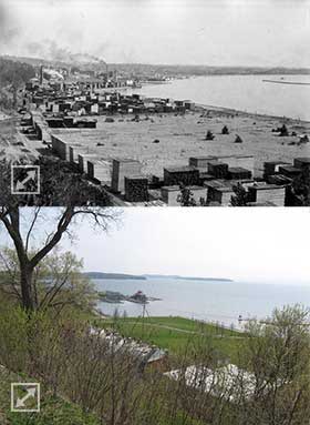
Top: Burlington's waterfront 1860-1880
with lumber yards.
Bottom: Contemporary photo of the same spotBeginning in the 1850s, lumber yards, train companies, power generating plants and water pumping facilities set up operations along the shore, inhabiting land created by filling the lake shore with sand excavated from the nearby dunes. When lumber profits waned in the early 20th century, the petroleum industry largely took over this portion of the shore. Tanks and bollards became flagships of the Waterfront skyline. As industrial transportation shifted from the lake to the roads, the structures on the Urban Reserve were gradually dismantled and removed. The Reserve is located in Burlington, Vermont north of the Burlington Sailing Center and south of North Beach.
The city purchased this 45 acre parcel in 1991 after an Urban Renewal Plan was approved by voters. An interim use and stewardship plan was adopted in 1997 that set an agenda for the next 15 years and emphasized open space, public access and conservation. In 2012, the voters of Burlington passed a bill to devote $6 million toward waterfront revitalization. Although changes to the Urban Reserve were not included in this bill, attention has been drawn to this area and an effort to revitalize the reserve through a well balanced, cooperative approach has developed.
After the removal of the last petroleum drum in 1994, the landscape of the Urban Reserve began to reestablish its own natural ecosystems. Wetlands sprung with cattails and willows, forests of cottonwood and ash took root, and birds, animals, and humans moved in to live and recreate. Neighboring the popular Waterfront Park, developing Waterfront North Property, and busy North Beach, the Urban Reserve is now poised to be managed and developed according the stipulations laid out in its initial conservation easement.
A Human-influenced Ecology
Since the removal of the industrial structures that once comprised the skyline of the Burlington Waterfront, portions of the Urban Reserve have developed into ecosystems that take advantage of the varying site criteria. From brush-hogged power line corridors to the majestic pitch pines on the eastern hills, the Urban Reserve has the potential to showcase unique lakeside environments that are accessible and inviting to the public. Soil types, local hydrology, disturbance, seed source and site-specific shading dictate the type of ecosystems found on the Urban Reserve.
Wetlands
The southern boundary of the Urban Reserve intersects a Class III wetland of approximately 1.1 acres. As described in the 1993 report by Champlain Consultants, The Urban Reserve Ecology Park: A Conservation Map and Reclamation Proposal for Burlington's Urban Reserve, the site was dominated by a mixture of wetland species including phragmites, cattail, willow and purple loosestrife. Standing water was present in the spring and saturated soil was visible through the summer and fall.
During the intervening 20 years, the wetland has filled in and dried. Small cottonwood and black willow now pop through the dense understory of invasive phragmites. In the spring of 2013, the wetland did not contain standing water, a condition necessary for wetland species. The following videos give more details about two plants species very common to this wetland area - black willow and horsetail (an "ancient sandpaper").

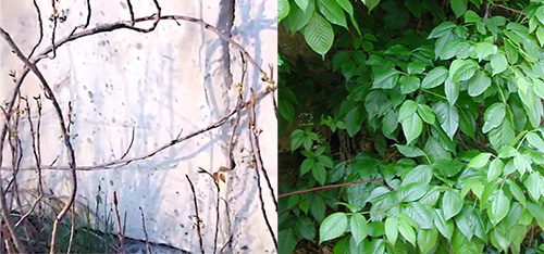
poison ivy
Poison Ivy
Abundant in several areas of the waterfront, Poison Ivy (Toxicodendron radicans) is a three-leaved plant that grows as a trailing vine, climbing vine or sometimes a shrub. Perhaps most easily identified by its shiny green and/or reddish leaves, this plant causes skin irritation in most people who touch it. During the spring (without its leaves) the plant is best identified by whitish-yellow berries. In the video, the vine climbs up a cement wall originally built to reinforce the raised railroad tracks.